Sunday, October 6, 2019

Puerto Rican road trips, the hurricane, the beach

Here's a question for you:

Is La Isla del Entanco (the Isle of Enchantment) a suitable getaway during the winter months? One way to find out is to walk the beach and drive the roads. Puerto Rico is barely 110 miles wide and 35 miles North to South. But  on one day, the road trip that should have taken only eight hours ended up taking about 12. And the beach was kinda ugly. Also,  the island hasn't fully recovered from Hurricane Maria yet.

Today's posting gives you part of the story of what the island is like.

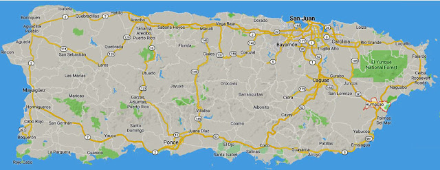
Puerto Rico's major roads; the island's spine is mountainous and the roads less maintained.

What's the name of this road?

Shortly after arriving in San Juan, I was in my SUV heading toward Palmas Del Mar, which  you can probably make it out on the map, above, in the southeast part of the island. My Garmin GPS wasn't set up yet, so I relied on my Verizon GPS and managed to make the resort in about 90 minutes despite a major obstacle: the GPS road names didn't match the highway signs. It took a lot of backtracking, but I made it, and after a couple days I got the hang of driving on the island.

But even when you can find your way around, things can go south on you in Puerto Rico. One day  I decided to go to the Arecibo Observatory to see one of the world's largest radio telescopes. The plan was to drive from Palmas Del Mar to San Juan (50 minutes); from there to Arecibo (45 minutes); then south to Utuado (40 minutes), Adjuntas (30 minutes), Ponce (30 minutes) and then back to the condo (2 hours). Drive time without stopping would have been five hours, so I expected the trip to take 8 hours. Thanks to two truck rollovers, the trip took 12-14 hours.
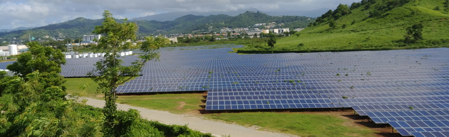
Solar farm

The day began with the fascinating view below -- an enormous solar farm, capturing the bright sunlight that keeps the ambient air temperature hovering at the 90s and above. The island also generates electricity with wind farms.


First rollover spoils the morning

After the fascination of viewing the solar farm, I faced the frustration of a freeway that had become a parking lot. I learned later in the day that somewhere between me and San Juan a truck had tipped over. My Verison GPS advised me there was a shorter route that could save me 30 minutes.

Yeah right. The "quick route" led me along curving mountain roads that occasionally became one lane, and which circled back to the place where I left the freeway. But at least after two hours of completing a circle, the slowdown was gone. Navigating the chaotic route through San Juan's freeway was daunting, but the Garmin miraculously got me on to the road toward Arecibo directly to the west, and on to the observatory.

Broken Spanish, Broken English

From Arecibo I headed south on bewildering, twisting narrow mountain roads, relying on my Garmin and a quick stop at a roadside cantina to verify that I was truly on the road to Utuado I headed down back roads to Utuado, then a small city called Adjuntas and finally Ponce. Soon after Ponce the freeway again became a parking lot.

Somewhere up ahead, probably because of a torrential downpour, a fuel truck had turned over. It was night. In broken Spanish and broken English I and two traffic cops determined an alternate route in the dark which, which was supposed to take me around the obstruction. Two hours after driving on dark streets and roads I found myself right back where I started, talking to the same two officers. The freeway was still blocked. I waited another hour or so until it opened up, about 9 p.m. I got home by midnight.

Roadside encounters

Not all my road trips were so aggravating. Here are some scenes from other trips I took.

Remember the solar farm?  This photo presents a contrast:

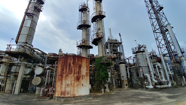
The not-quite-dead carcass of the CORCO oil refinery

The photo above shows remnants of the CORCO oil refinery located at  Tallaboa, PeƱuellas, Puerto Rico. It had once been among the 500 largest companies in the United States, supplying 80 percent of all petroleum products consumed in Puerto Rico. With 2,700 employees, it was island's largest employer and was "among the largest independent petroleum refiners and petrochemical producers in the world." CORCO purchased Venezuelan oil, and the 1970s oil embargo signaled its coming decline. It reportedly functions as a terminal for marine transportation and land-based storage of crude oil, but it's also considered to be a hazardous waste site subject to EPA cleanup.

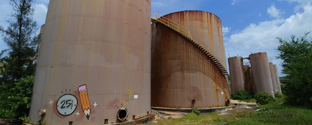
Located near the sea at Arecibo, these appeared to be abandoned petroleum tanks.
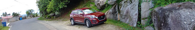
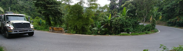

Mountain roads

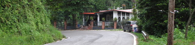
The photo below shows what a street at the resort community might look like -- wide and flat, with good visibility.


The photo below is a typical mountain road -- narrow, with buildings hanging next to the road on a steep hillside. On one trip I considered -- and rejected -- the idea of descending one road because of the sharp curve it made near the bottom, where there was no guard rail. Miss that curve and I could have gone airborne. There was no way I was inclined to go down that incline.

Not an atypical scene: A house clings to a cliff; stonework makes the guard rail by the road.

Large boulders by this narrow two-lane road reveal volcanic origins.


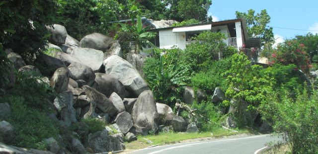
Don't you kind of wonder what prompted all those boulders to gang up by the road there?


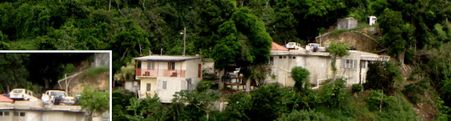
Space on a mountain side a precious. Note the cars parked atop a house (see inset).

Cars nestle into the only flat space by a home perched on a hillside next to a narrow, sharp curve.

The lizard in the inset photo was that tiny speck on the edge of the wheel well.

No road for daydreamers

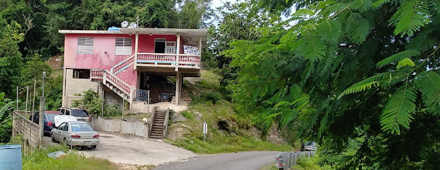
Concrete is a common home-building material in the mountains. It seems to survive the onslaught of weather and jungle. And it may also be good protection from the traffic that passes by, as indicated in the following photos. The house is next to a deep ravine. The trucks shown below are rounding a curve around the ravine, where chunks of the concrete guardrail are missing. Were they knocked aside in accidents, or washed away in Hurricane Maria? Best to keep your eye on the road here.

The homeowner's vehicle is barely off the road at this curve.

The ravine surrounded by this two-lane curve is missing a couple cement barriers.

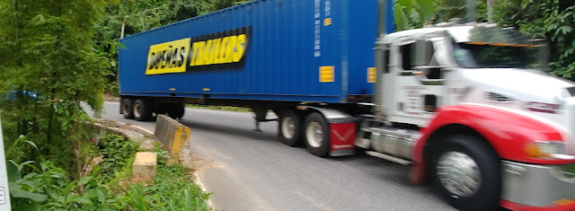
Descending past this curve by the ravine, the truck honked and used both lanes to make the turn.

A free meter.

Never feed the meters in Ponce!

After a few hours of white-knuckling back mountain roads, I reached Ponce, which is located in what might be described as a coastal plain. I showed up around 6 p.m., which was fortunate, because all the downtown cartage traffic was gone by this time and there were parking spots. As I grabbed a meal at the local Burger King, I worried about what kind of coin you put in the meter.

Well, not to worry. The parking meters are relics and no-longer used. What good fortune!

Tracks of Maria

Sharp-eyed readers may have noticed that the road the trucks were using by the ravine was smooth and fresh looking. Mountain roads have lots of potholes, but there are places where they have clearly been repaired. And the work continues.

On my first road trip I encountered this curve under repair.

This heavy-duty saw looks to be designed for cutting concrete.

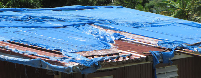
It's been two years, but some homeowners are still depending on plastic to keep the rain out.

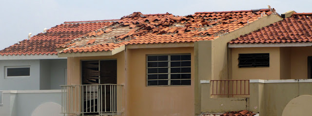
Two years after Maria, the resort is still making repairs. Note the doorway, as well as the roof tiles.

The resort I was at was pretty posh. But there was evidence that Maria had a lingering impact. Normally the time share condos have a full compliment of kitchen ware. But mine lacked a potato masher and a whisk. One wine glass was missing a section. There were too few drinking glasses, and the chip that abandoned one of those glasses had left little slivers of itself behind for me. There was no dish towel or hot pad. My room lacked a phone to reach the front desk. And during my stay there was noisy work performed on the roof and repairs being made to the lagoon outside my unit.

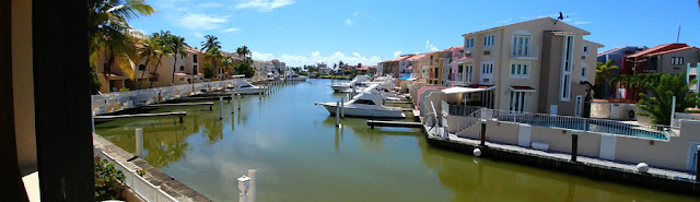
Rich people live here, but Maria didn't care.  Pilings here are being repaired.

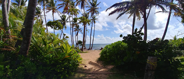
This beach access view is lovely, but Maria wiped out the tourist comfort infrastructure.

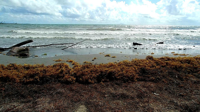
Sargassum seaweed clutters the beach. Click here for the video.

Most people have heard of the Sargasso Sea. Did you ever wonder where it was? It's just to the northeast of Puerto Rico. I've provided a map so that you and the president can know where Puerto Rico is situated (a little bit east of Cuba).  The yellow arrows on the map indicating the current show why the sargassum piles up on the enchanted isle.

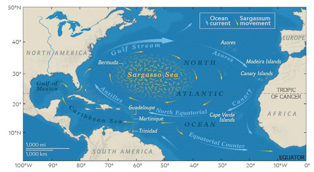
That tiny little blip to the west of the word, "Guadeloupe" is our possession, Puerto Rico.


At one time this beach was outfitted with lots of umbrellas and other accouterments. They are gone now. The chaise lounges are stacked and locked on a nearby bank. They are unlocked for the occasional tourist who wants to sit on the beach.

Regardless of the beach's condition, the turtles still visit:

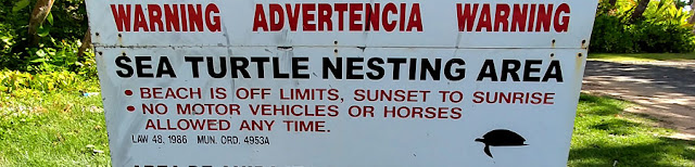
Signs remind the tourists to leave the nesting turtles alone. . .


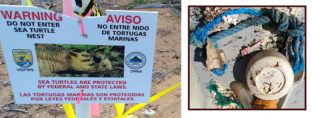
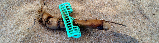
. . . but those signs don't prevent the plastic detritus from gathering in their nesting grounds

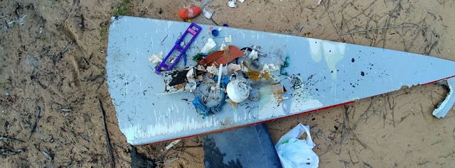
I spent 15 minutes one day prowling the beach for plastic. Along with the small items I found a broken surf board that I dragged ashore:

Yum! Kinda looks like a pizza slice, doesn't it?

This hair curler took a shine to a root of some sort.

You may recall if you read an earlier blog that I found ants crawling all over me the last time I was on the beach. This time I exercised a little more caution. I had several infections from the bites and notified my HMO. Based on their advice I washed the area around the infected bites, punctured and drained the wounds, then bathed the area with hand sanitizer. It stung,  a bit, but that took care of the problem. The photo below shows what the infections looked like.

The infections on the ant bites on my left calf.

Well, I think I have one final posting to wind up my Puerto Rico report. The final post will focus on some aspects of the island's beauty.

Love,
Robert

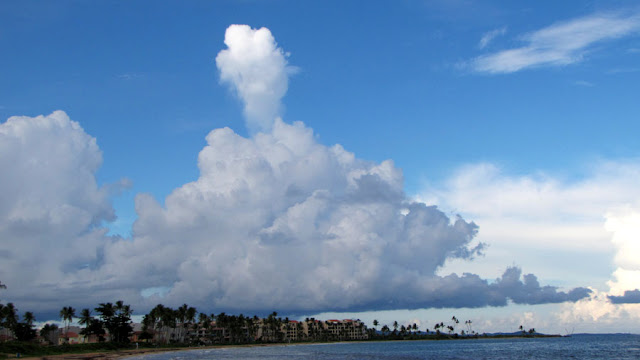
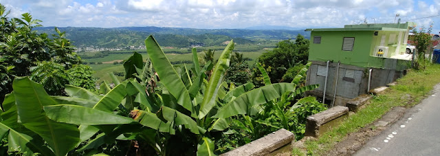
Storm clouds gather along the eastern coast of Puerto Rico, where the lowlands meet the sea.


Sunday, September 29, 2019

Strange fruit, radio bursts, exoplanets: shameless chef is home

A hefty root of malanga awaits its fate on the chopping board.


Hello, Marian,
Yes, this installment of Spirit of Wilson is being dispatched to the usual recipients, but just to be different, it is being sent as a letter to you, a friend I've known for more than 50 years. As a resident of Maui, I thought you might be interested to know how similar Maui is to Puerto Rico, the land of Hurricane Maria.

Except for the absence of molten rock that can burn you, and the strong Hispanic culture, Puerto Rico is a lot like Maui. For each island, what we call civilization has developed detente with the jungle, but it is an uneasy truce, with the jungle always testing the boundaries.

 Puerto Rico is a mere 150 miles closer to the equator than Maui. Because of their locations, both islands have important observatories. In 1992, the Arecibo Observatory in Puerto Rico announced the first planet to be discovered outside our solar system.

Malanga -- the new potato?


I made a far less momentous but nonetheless pleasing discovery of my own -- malanga, a root crop which is related to Hawaii's famous root crop, taro. Malanga is tasty, nutritious and filling, and kind of nutty, like the chef. If possible I intend to substitute it for the more pedestrian potato.  So far I haven't found malanga in Seattle, but I spent my last day in Puerto Rico experimenting with it as I packed and cleaned out the fridge.

Puerto Rico is a U.S. possession, with all the benefits of being possessed -- lots of Burger Kings and McDonald's restaurants to rely on when you are on the road and can't be sure a food server will speak English.  (Yes, yes, I know: if they can't learn English, why don't they go back to their own country, right?)

Plantain dish left; avocado, right.

The resort had a restaurant where I tried a dish of pork and other delicacies presented in small cups of fried plantains pictured at the right. The filling was great, but the plantains just seemed too starchy.  An exotic avocado, however, was enormous, very creamy and almost sweet. I purchased it from a vendor at the Pietra Escrita (petroglyphs) near a community called Jayuya in Central Puerto Rico. I was dubious, but it turned out all right.


A trip to Walmart made it possible to provision my condo with standard stuff a shameless cheapskate bachelor eats -- ham steaks,  lunchmeat, cheese, jam, bread, yogurt, pizza, beer,  ketchup, mustard, juice, etc. You know -- health food.

$4 for that hunk of malanga, and $3 for a bunch of bananas -- far, far pricier than Trader Joe's

It  was also at Walmart where I discovered malanga. Later, I purchased the specimen at the top of this article at the  roadside stand in the photo immediately above, while enroute to see what used to be the world's largest radio telescope.  I had already tried mashing malanga and garnished it with ketchup. Yum! This time I tried dicing and frying it. My recommendation is to stick with mashing it.

Malanga reportedly originated in South America and is now grown in the Caribbean, Central America, and certain parts of Africa and Asia. My research discovered that it is a natural thickener, and makes stews and soups creamy. However, when eaten raw, it can irritate the throat.

Honeyed ham: Yum!

The rest of the fridge cleanout involved dicing the ham steaks and slathering them with honey; eating the remaining yogurt and a ripe pineapple. Adding beer to the fried diced malanga in hopes that it would salvage it and contribute an interesting flavor (it didn't); and stuffing myself with that humongous avocado. This particular variety seemed green and quite hard, but ripened quickly. It was actually hollow around the seed, which almost fell out when the fruit was sliced, and which shed a thin jacket of tissue.

Peeled malanga, ready to be diced


On the left, fried malanga, didn't work. On the right, cooking it with beer didn't work either.

The Arecibo Observatory


Arecibo Observatory

Oh, I mentioned the world's largest radio telescope. Maybe you're curious about that. Here's a photo of it: This thing is 1,000 feet across. It rests in a depression in the ground carved in large part by ground water that naturally ate away at the limestone in the region, creating natural depressions that the telescope could be fitted into.

The undulating earth

There are many of these depressions in what is described at karst topography. The term is taken from a region between Yugoslavia and Italy. For Puerto Rico, it has resulted in places with a land form that looks a little bit like the undulations in ribbon candy, or like a sine wave. The photo below of a truck on the expressway shows how the land undulates, creating natural depressions into with such a telescope could be fitted. One third of the island has karstic topography.

Karst topography in the mountainous area south of Arecibo.

Exoplanets and radio bursts

Arecibo has the distinction of discovering the first exoplanet (a planet outside our solar system). It has served the National Science Foundation, and was able to help NASA troubleshoot problems with an earth satellite by determining whether it was tumbling in orbit. Literature at the observatory stated that the Arecibo telescope was the first to discover split-second "fast radio bursts" in the Northern hemisphere of the sky.

4 miles of cables, each weighing 10 tons, support the 1,000-ton platform above the dish.

Arecibo is no longer the world's largest radio telescope.It has been eclipsed by the much larger FAST radio telescope, in China. (However, the Chinese telescope doesn't have the distinction of appearing in a James Bond film. )The Arecibo telescope has a limited range of view, but was aimed in the right direction to help out Nasa with that tumbling satellite.  Unfortunately, the future funding of the observatory is somewhat in doubt.

Love,
Robert


Tuesday, September 17, 2019

Thorns, pirates and bioluminescence

The Jolly Roger reigns over Las Croabas Park in Fajardo, Puerto Rico.

When you live on the West Coast, Puerto Rico seems like a long ways away. But the fact is, it's cheaper to fly to this tropical isle  than to Hawaii. Yesterday I was treated to something that I don't think Hawaii has -- biolumiscence -- water that glimmers with light as falls from your hand.

Unfortunately, you can't take a photo of bioluminescence. It's bright enough to see, but impossible to photograph. So you'll have to take my word for it. The excursion I went on was located in a little city called Fajardo, at Las Croabas Park.

Before I went there, I spent part of the morning strolling the humongous resort where I can afford to stay by using time share credits. I got up early to examine some damage to my rental car from a brush-and-run from the night before. (More on that in a future blog.) Then I walked around the grounds a bit, taking in some of the interesting foilage, such as the tree, below.

What an amazing trunk; you are looking at a root that is probably 3.5 feet high, at least.

Another view of this amazing tree, with roots that reach down the bank.


Then as I was walking along the road, I took a closer look at a tree I previously had thought was rather ordinary looking. When you get close you realize this species of tree seems to have an anti-social personality disorder. Nothing personal about it -- it doesn't care if you lean against it -- but you certainly will.

Big, stubborn, unforgiving three-quarter-inch thorns aim in every direction.


Don't try using this limb for chin-ups.

I doubt that I will ever see
A monster meaner than this tree.

Those thorns reminded me of what was once called the Iron Maiden, the hollow shell that held prisoners and which was festooned with interior spikes. Except, of course, that the Iron Maiden was a fiction. This tree, however, is a fact.

Here are some friendlier examples of the flora at the resort.


Malanga -- replaces spuds, reduces blood pressure

Toward the end of the day I headed out for my excursion. Along the way, I stopped at Walmart to shop for malangas, pictured below. This is a remarkable root vegetable. You can mash it just like potatoes. I made some just before writing this post. It is quite good and quite filling, and it is supposed to help with high blood pressure. I'm going to be looking for this and other Puerto Rican root vegetables after I get back to Seattle.


I planned an early arrival for the bioluminesence tour, which technically was about a 40-minute drive from the resort.
Technically.
Getting around Puerto Rico by auto isn't difficult, once you get the hang of it, but using GPS can be a bit iffy because the street names are not always posted and freeway exits could be more obvious. So you have to trust the GPS, and it's not always spot on.

Dollar Rent A Car charged me $11 a day for a Nissan Sentra, and then upgraded me to a Hyundai Tucson because they didn't have the compact in stock. They also would have charged me $13 per day for a Garmin brand GPS device,  after warning me that Verizon's GPS system was unreliable. Actually, I found Verizon's GPS pretty reliable, but I used a Garmin as well. For the price of renting one, I could simply purchase one. Neither device is 100 percent correct, but if you stay cool you can get where you're going.

When I got to Las Crobas Park, I found pirates -- sort of. The folks got creative with the big toys, which were made out to be imaginary pirate ships. I hadn't seen anything so creative in big toys.

Pirates ahoy! With a little imagination, the kids become swashbucklers.

This is the business end of the port canon near the ship's bow.


At a small cafe by the park I dined on bits of pork and paella -- a rice and corn cake.

Too dark to photograph

And here's where the photos end. Even though there was a bit of cloud cover, the moon was full and that meant light pollution. That and the gentleness of the glow in the water made it impossible to photograph the bioluminiscence. However, it was just dark enough to poke your eye out if you didn't watch where you were going and drifted into a mangrove branch.

Mangroves essential for the night lights


The mangroves are part of the reason for the bioluminescence. The plankton that produce it pour from the ocean into this mangrove estuary, and the chemicals from the mangroves as well as the temperature of the water are just right to support the animals that make the glow. When I stirred the water with my hand, it became engulfed in a white smoke-like glowing cloud. When I splashed the water onto the edge of the kayak, the ocean water looked like shimmering droplets of mercury running across the surface of the boat. Puerto Rico is one of the best places in the world to see this phenomenon.

My under-powered vessel


My kayak was under powered and slow. All other kayaks had two paddlers aboard. I rode solo and it was a chore keeping up and maneuvering in the dark through the channels of the mangroves. The twisting channel eventually reached quiet open water where we tied up together and played with the planktons, before returning to shore. The excursion was a three-mile round trip, according to one guide. Toward the end I accepted his offer to give me a bit of a tow, which made catching up with the others a lot easier. No shame here; I had been doing the work of two. And unlike two couples in our group, I managed not to flip my kayak.

Rubber knees


I was surprised I didn't get blisters on my palms, and more surprised when I tried to stand up after exiting the kayak. It's not unusual for newbies to have rubbery legs when they exit the craft, and the waves of the ocean can give you a tumble. The guide had to hold me up to get me up the steps on the bank. I put my arm around him and held on. Twenty years from now, I may not need the excuse of kayak exhaustion to require that kind of help. Was this a premonition of things to come? Where did I stash that walker?

Love,
Robert