Here's a question for you:
Is La Isla del Entanco (the Isle of Enchantment) a suitable getaway during the winter months? One way to find out is to walk the beach and drive the roads. Puerto Rico is barely 110 miles wide and 35 miles North to South. But on one day, the road trip that should have taken only eight hours ended up taking about 12. And the beach was kinda ugly. Also, the island hasn't fully recovered from Hurricane Maria yet.
Today's posting gives you part of the story of what the island is like.
 |
Puerto Rico's major roads; the island's spine is mountainous and the roads less maintained.
|
What's the name of this road?
Shortly after arriving in San Juan, I was in my SUV heading toward Palmas Del Mar, which you can probably make it out on the map, above, in the southeast part of the island. My Garmin GPS wasn't set up yet, so I relied on my Verizon GPS and managed to make the resort in about 90 minutes despite a major obstacle: the GPS road names didn't match the highway signs. It took a lot of backtracking, but I made it, and after a couple days I got the hang of driving on the island.
But even when you can find your way around, things can go south on you in Puerto Rico. One day I decided to go to the Arecibo Observatory to see one of the world's largest radio telescopes. The plan was to drive from Palmas Del Mar to San Juan (50 minutes); from there to Arecibo (45 minutes); then south to Utuado (40 minutes), Adjuntas (30 minutes), Ponce (30 minutes) and then back to the condo (2 hours). Drive time without stopping would have been five hours, so I expected the trip to take 8 hours. Thanks to two truck rollovers, the trip took 12-14 hours.
Solar farm
The day began with the fascinating view below -- an enormous solar farm, capturing the bright sunlight that keeps the ambient air temperature hovering at the 90s and above. The island also generates electricity with wind farms.
First rollover spoils the morning
After the fascination of viewing the solar farm, I faced the frustration of a freeway that had become a parking lot. I learned later in the day that somewhere between me and San Juan a truck had tipped over. My Verison GPS advised me there was a shorter route that could save me 30 minutes.
Yeah right. The "quick route" led me along curving mountain roads that occasionally became one lane, and which circled back to the place where I left the freeway. But at least after two hours of completing a circle, the slowdown was gone. Navigating the chaotic route through San Juan's freeway was daunting, but the Garmin miraculously got me on to the road toward Arecibo directly to the west, and on to the observatory.
Broken Spanish, Broken English
From Arecibo I headed south on bewildering, twisting narrow mountain roads, relying on my Garmin and a quick stop at a roadside cantina to verify that I was truly on the road to Utuado I headed down back roads to Utuado, then a small city called Adjuntas and finally Ponce. Soon after Ponce the freeway again became a parking lot.
Somewhere up ahead, probably because of a torrential downpour, a fuel truck had turned over. It was night. In broken Spanish and broken English I and two traffic cops determined an alternate route in the dark which, which was supposed to take me around the obstruction. Two hours after driving on dark streets and roads I found myself right back where I started, talking to the same two officers. The freeway was still blocked. I waited another hour or so until it opened up, about 9 p.m. I got home by midnight.
Roadside encounters
Not all my road trips were so aggravating. Here are some scenes from other trips I took.
Remember the solar farm? This photo presents a contrast:
 |
The not-quite-dead carcass of the CORCO oil refinery
|
The photo above shows remnants of the
CORCO oil refinery located at Tallaboa, Peñuellas, Puerto Rico. It had once been among the 500 largest companies in the United States, supplying 80 percent of all petroleum products consumed in Puerto Rico. With 2,700 employees, it was island's largest employer and was "among the largest independent petroleum refiners and petrochemical producers in the world." CORCO purchased Venezuelan oil, and the 1970s oil embargo signaled its coming decline. It reportedly functions as a terminal for marine transportation and land-based storage of crude oil, but it's also considered to be a hazardous waste site subject to EPA cleanup.
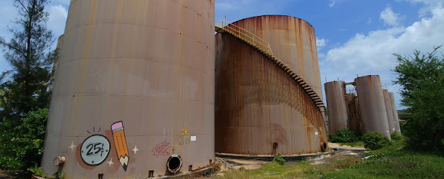 |
Located near the sea at Arecibo, these appeared to be abandoned petroleum tanks.
|
Mountain roads
The photo below shows what a street at the resort community might look like -- wide and flat, with good visibility.
The photo below is a typical mountain road -- narrow, with buildings hanging next to the road on a steep hillside. On one trip I considered -- and rejected -- the idea of descending one road because of the sharp curve it made near the bottom, where there was no guard rail. Miss that curve and I could have gone airborne. There was no way I was inclined to go down
that incline.
 |
Not an atypical scene: A house clings to a cliff; stonework makes the guard rail by the road.
|
 |
Large boulders by this narrow two-lane road reveal volcanic origins.
|
 |
Don't you kind of wonder what prompted all those boulders to gang up by the road there?
|
 |
Space on a mountain side a precious. Note the cars parked atop a house (see inset).
|
 |
Cars nestle into the only flat space by a home perched on a hillside next to a narrow, sharp curve.
|
 |
The lizard in the inset photo was that tiny speck on the edge of the wheel well.
|
No road for daydreamers
Concrete is a common home-building material in the mountains. It seems to survive the onslaught of weather and jungle. And it may also be good protection from the traffic that passes by, as indicated in the following photos. The house is next to a deep ravine. The trucks shown below are rounding a curve around the ravine, where chunks of the concrete guardrail are missing. Were they knocked aside in accidents, or washed away in Hurricane Maria? Best to keep your eye on the road here.
 |
The homeowner's vehicle is barely off the road at this curve.
|
 |
The ravine surrounded by this two-lane curve is missing a couple cement barriers.
|
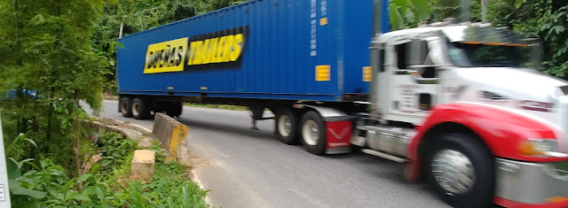 |
Descending past this curve by the ravine, the truck honked and used both lanes to make the turn.
|
 |
A free meter.
|
Never feed the meters in Ponce!
After a few hours of white-knuckling back mountain roads, I reached Ponce, which is located in what might be described as a coastal plain. I showed up around 6 p.m., which was fortunate, because all the downtown cartage traffic was gone by this time and there were parking spots. As I grabbed a meal at the local Burger King, I worried about what kind of coin you put in the meter.
Well, not to worry. The parking meters are relics and no-longer used. What good fortune!
Tracks of Maria
Sharp-eyed readers may have noticed that the road the trucks were using by the ravine was smooth and fresh looking. Mountain roads have lots of potholes, but there are places where they have clearly been repaired. And the work continues.
 |
On my first road trip I encountered this curve under repair.
|
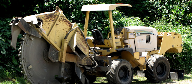 |
This heavy-duty saw looks to be designed for cutting concrete.
|
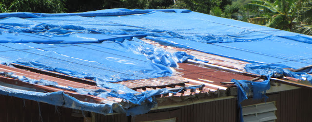 |
It's been two years, but some homeowners are still depending on plastic to keep the rain out.
|
 |
Two years after Maria, the resort is still making repairs. Note the doorway, as well as the roof tiles.
|
The resort I was at was pretty posh. But there was evidence that Maria had a lingering impact. Normally the time share condos have a full compliment of kitchen ware. But mine lacked a potato masher and a whisk. One wine glass was missing a section. There were too few drinking glasses, and the chip that abandoned one of those glasses had left little slivers of itself behind for me. There was no dish towel or hot pad. My room lacked a phone to reach the front desk. And during my stay there was noisy work performed on the roof and repairs being made to the lagoon outside my unit.
 |
Rich people live here, but Maria didn't care. Pilings here are being repaired.
|
 |
This beach access view is lovely, but Maria wiped out the tourist comfort infrastructure.
|
 |
Sargassum seaweed clutters the beach. Click here for the video.
|
Most people have heard of the Sargasso Sea. Did you ever wonder where it was? It's just to the northeast of Puerto Rico. I've provided a map so that you and the president can know where Puerto Rico is situated (a little bit east of Cuba). The yellow arrows on the map indicating the current show why the sargassum piles up on the enchanted isle.
 |
That tiny little blip to the west of the word, "Guadeloupe" is our possession, Puerto Rico.
|
At one time this beach was outfitted with lots of umbrellas and other accouterments. They are gone now. The chaise lounges are stacked and locked on a nearby bank. They are unlocked for the occasional tourist who wants to sit on the beach.
Regardless of the beach's condition, the turtles still visit:
 |
Signs remind the tourists to leave the nesting turtles alone. . .
|
 |
. . . but those signs don't prevent the plastic detritus from gathering in their nesting grounds
|
I spent 15 minutes one day prowling the beach for plastic. Along with the small items I found a broken surf board that I dragged ashore:
 |
Yum! Kinda looks like a pizza slice, doesn't it?
|
 |
This hair curler took a shine to a root of some sort.
|
You may recall if you read an earlier blog that I found ants crawling all over me the last time I was on the beach. This time I exercised a little more caution. I had several infections from the bites and notified my HMO. Based on their advice I washed the area around the infected bites, punctured and drained the wounds, then bathed the area with hand sanitizer. It stung, a bit, but that took care of the problem. The photo below shows what the infections looked like.
 |
The infections on the ant bites on my left calf.
|
Well, I think I have one final posting to wind up my Puerto Rico report. The final post will focus on some aspects of the island's beauty.
Love,
Robert
 |
Storm clouds gather along the eastern coast of Puerto Rico, where the lowlands meet the sea.
|




No comments:
Post a Comment